Mountainous Borchali – is a highland region within the ancient Borchali province. Today, this portion of Borchali, which remained part of the Armenian SSR, is known as Loru. Following the Russian occupation of Borchali on September 12, 1801, the Borchali district was established within the Georgian governorate. In 1880, Borchali uezd was founded within the Tbilisi governorate, with its largest district being Loru. Due to its location in the mountainous part of Borchali, Loru district is commonly referred to as Mountainous Borchali. According to historical sources, the area known as Loru once housed the city of Loru. The city was destroyed by the Mongols in 1236, rebuilt in the 14th-15th centuries, and faced attacks from the Ottomans and Iran during the 15th-18th centuries. Turkic sources from 1590 and 1727 mention the villages of Chakrashan (Chakrashin) and Otarshen in the Loru district of the Borchali region. The compilation of Turkic villages in the Loru/Lori district from 1802 reveals the presence of Turkic villages in other neighboring districts during that period: Fakhrali, Gizilhajili, Kolagir/Kolayir in the Gazakh district, Gachagan, Saral, Hamamli in the Pambak district, and Gullar, Gushchu, Ghirikhli villages in the Shamshaddil district. One of the most intriguing aspects of Loru district’s history is the existence of the ancient Loru Turkic fortress. Nevertheless, this fortress fell to the Mongols’ destruction in 1236, underwent reconstruction during the 14th-15th centuries, and endured severe assaults by Iranian and Ottoman forces in the 15th-18th centuries.
In the early 18th century, the entire Borchali region, including the Loru district, was under the jurisdiction of the Ganja Beylerbey. However, Ziyadoghlu, the ruler of Ganja, opposed the declaration of Nader Shah Afshar as the shah in Mughan in 1736. Consequently, following Nader Shah Afshar’s ascension to the throne, he reorganized the governance by transferring control of the Borchali and Gazakh districts from Ganja and placing these territories under the rule of the Kingdom of Kartli-Kakheti.
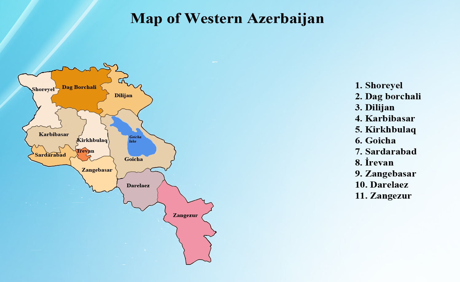
After the Armenian-Georgian war in December 1918, Borchali underwent a division into two distinct parts. In 1921, an agreement was reached between the Bolshevik governments of Georgia and Armenia to transfer this region to Armenia. Mountainous Borchali was ceded to the Armenian SSR, while the plain parts of Borchali (Aran Borchali) remained in Georgia. Until 1921, Georgians referred to this area in the territory of present-day Armenia as ‘Javakhetia,’ and the Azerbaijanis living in Georgia called it ‘Mountainous Borchali’. One side of these territories is adjacent to Georgia’s Dmanisi and Akhalkalaki regions, while the other side adjoins Armenia’s Jalaloghlu (now known as Stepanavan) settlement. The territory of this area includes extensive mountain ranges and fertile foothills, with its borders extending into the territory of Türkiye. Historically, this area has also served as pasturelands for agricultural purposes by the population of Gazakh district in Azerbaijan, as well as the districts of Garachop, Garayazi, and Borchali in Georgia. Mountainous Borchali, situated in the northeastern reaches of Armenia, is flanked by the Garakhach Range (now referred to as the Javakhet Range) and the Aghlaghan Mountains (presently recognized as the Bazum Range). The territory is also bordered by the border line of the Republic of Armenia with the Republic of Georgia and the Republic of Azerbaijan. The southern part of Borchali, known as Loru, was annexed by Armenians. In a manner reminiscent of their annexation of Zangazur to Armenia under the guise of false internationalism, they divided Borchali into two parts and incorporated the southern portion into Armenia. This annexation also included the Gumushkhana, Allahverdi, Shamlig, Aghtala, and Tambulat gold and silver deposits. These mining sites, originally established by the Georgian governor Irakli II in 1763 with the assistance of the Greeks, now remained under Armenian control.
During the Soviet era, several renaming actions took place in the region. Mountainous Borchali was renamed Kalinin, Jalaloghlu was renamed Stepanovan, Alaverdi was renamed Tumanyan, and Barana was renamed Noyanberyan. In 1937, a district named Kalinino was established within Mountainous Borchali. Presently, Armenians refer to this region as Tashir. Historical records indicate that the name ‘Tashir’ has been associated with this district since the 5th century. Interestingly, ‘Tashir’ is of Turkic origin, meaning ‘Stone place’ or ‘Rocky place’ in Turkic languages. Researchers suggest that it is the ancient name for the area subsequently referred to as Lori. It’s worth noting that the toponym ‘Tashir’ was not altered by Armenians due to their unawareness of its Turkic origin. Since the 1930s, Azerbaijani place names in regions taken from Georgia and ceded to Armenia, which were originally inhabited by Azerbaijanis, have undergone changes. These names were substituted with fictitious Armenian appellations.
The region is rich with toponyms such as “gara dash”, “gara arkhach”, “garanlig dara”, “gara yal” which serve as its historical nomenclature. This expansive land, graced by extensive pastures and meadows, has borne the name ‘Garakhach’ highland since time immemorial. The toponym ‘Mountainous Borchali’ has been expunged from memories due to the deliberate removal of the Azerbaijani population from the region, a result of the orchestrated ethnic cleansing perpetrated during the Soviet Union era. Nowadays, ‘Borchali’ predominantly invokes thoughts of ‘Aran Borchali,’ the plain section of the region located within Georgia.
According to E.D. Eritsov, “Armenians have migrated to the Borchali territory on several occasions.” Armenians migrated to Mountainous Borchali (Loru) and Jalaloghlu (now Stepanavan) from diverse provinces of the former Iravan Khanate. Furthermore, Armenians from Erzurum established communities in the Barmaghsiz territory (now Zalga prefecture), while Armenians from Karabagh settled along the banks of the Khram River. Historical records indicate significant Armenian migrations. In 1873, 107 Armenian families (comprising 877 individuals) settled in Jalaloghlu, and by 1887, this number had increased to 232 families, totaling 1630 people. Interestingly, the Gypsies who initially came from Erzurum to the village of Tamala Kharaba in Barmaghsiz eventually assimilated into the Armenian community. It’s worth noting that Borchali is a diverse region, encompassing elements of Karabakh, Nakhchivan, Shirvan, Ganjabasar, and the Iravan Khanate, as it is home to representatives from all these regions.
Zaur Aliyev, associate professor